Friday, September 6, 2019

Friday morning


Friday a.m.: Emergency Management Coordinator Andrew Jacobs says this morning that Hoke fared well during the storm. No reports of serious damage in this county.
Meanwhile, total precipitation associated with the storm as of this morning.precipitation associated with Dorian thus far.

Thursday, September 5, 2019

Thursday, 8:20 p.m.

The National Hurricane Center reports the center of Dorian is very close to Cape Fear, N.C. "Hurricane Dorian is centered as of 8 p.m. EDT about 60 miles (95 km) south of Wilmington, N. Carolina. It's moving toward the northeast near 10 mph (17 km/h), and this general motion is expected to continue with an increase in forward speed through Saturday. On the forecast track, the center of Dorian will move near or over the coast of North Carolina tonight and Friday."

Sustained winds are at about 100 mph now
At The News-Journal office we have 1.13 inches of rain and wind gusts topping out at 33 mph. Barometer continues to drop, now 29.60

5 p.m. Report


At 5 p.m. Thursday, Dorian has weakened a tad, according to the National Hurricane Center, but its minimum pressure at 960 mbar has it still a Cat 3 hurricane on the Saffir Simpson scale.

Not much has changed in its forecasted movement and that means Hoke's heaviest weather is from now until about 2 a.m.

Here at The News-Journal at 5 p.m. we have had .68 inches of rain with wind gusts to 29 mph. The forecast map divides Hoke County right down the middle, with the eastern half forecast to receive 4-6 inches of rain, and the western, 2-4.

Andrew Jacobs, Emergency Management Coordinator, there's been no serious damage in Hoke County reported, nor sustained power outages.

Power outages reported by Duke are shown in this map


Lumbee River is reporting about 50 customers without power in three counties, Hoke, Robeson and Cumberland.


2 p.m. Thursday

Here is current power outage map for Duke Energy 
Wind has picked up a bit. We've recorded gusts around 25 mph at the News-Journal office downtown, and we're in a protected area.
Rainfall is .36 here.

Latest info from National Weather Service is 1-4 inches of rain between US 1 and I-95 (that's us) with some localized flooding possible— greatest threat of flooding between 5 p.m. today and noon tomorrow.

Storm at 11:30 a.m. Thursday

The 11 a.m. advisory from the National Weather Service indicates slight weakening of winds in Dorian, but the storm remains Cat 3 as it approaches N.C.
Winds should begin to increase in this area soon, getting strongest late this afternoon and tonight. We remain under a tropical storm warning. Winds are expected in the 25-35 mp range with gusts to 50 mph
Damage prospects: "- Damage to porches, awnings, carports, sheds, and unanchored
mobile homes. Unsecured lightweight objects blown about.
- Many large tree limbs broken off. A few trees snapped or
uprooted, but with greater numbers in places where trees
are shallow rooted. Some fences and roadway signs blown
over.
- A few roads impassable from debris, particularly within
urban or heavily wooded places. Hazardous driving
conditions on bridges and other elevated roadways.
- Scattered power and communications outages.
Rain expected up to 4 inches.

Graphics say it all

The graphics say it all. Still expecting heaviest weather mid-afternoon to tomorrow morning.

Thursday at 7 a.m.


This morning's current radar image.


As Dorian makes its way toward us, the Nat. Weather Service says our heaviest weather will be between 2 p.m. today and 4 a.m. tomorrow:

Along the I-95 corridor between 4-8 inches can be  expected and 1-4 inches between US 1 and I-95. Minimal impacts will  be observed west of Highway 1. Similar story for the expected winds  as Max Wind gusts could top 60 mph in the southeast with 30-50 kt  gusts between US 1 and I 95. Expect less than 30 mph across the  Triad. Max sustained winds could be as high as 40-50 mph in the  extreme southeast.  


Wednesday, September 4, 2019

County declares emergency

Hoke Commission Chairman James Leach on Wednesday evening declared a state of emergency in the county. Under terms of the declaration, no curfews were set nor where there any evacuations ordered.

Wednesday Afternoon Update - Hurricane Dorian

Wednesday, September 4, 2019 - 4:50 p.m.

Takeaways from the commissioners' emergency meeting on Hurricane Dorian:
-Hoke County Schools are closed Thursday *and* Friday.
-No emergency shelters are planned to open for now, but if conditions require a shelter, county staff can have one opened within an hour of the decision.
-Hoke County government offices will close Thursday and operate on a 2-hour delay Friday.
-The Emergency Operations Center (EOC) will fully activate tonight, and the county plans to declare a local state of emergency.

As for the storm itself:
-Dorian is still a Category 2 hurricane, and looks to impact the North Carolina coast over the next 24-48 hours.
-Hoke County will likely start to see light rain later tonight, and conditions will worsen early Thursday morning
-Predictions are for 2-4 inches of rain, up to 6 inches in some places, and winds up to 35 miles an hour with wind gusts in the 50 mph range
-While the impact depends on the exact track and storm speed, for now it appears Dorian will be an all-day affair Thursday and clear out by Friday morning.

Thanks to all our readers, please be safe, and we'll update as the situation warrants.
-Catharin

Tropical Storm Warning

Hoke County is now under a Tropical Storm Warning. The Hoke County Board of Commissioners has called an emergency meeting set for 4 p.m. today to discuss hurricane preparations. The county has not decided whether to open a temporary emergency shelter, but the school system offered West Hoke Middle School as a location if officials do decide to open one.

-Catharin

Wednesday Morning

Hoke under tropical storm watch, flash flood watch, 4-8 inches of rain possible, winds potential 39 to 57 mph....
Latest tweaks from National Weather Service: "The biggest changes in the models since the last
update appear to be with the timing, slowing the acceleration of the
hurricane slightly. With the slow down expect the peak impacts to
occur from Thursday evening into Friday morning. Updates to the
forecast with this cycle include delaying slightly the onset time
for precipitation across the southern counties and on the opposite
end, moving the end time back in the east until later Friday
afternoon. Not all models are showing this decrease in forward speed
however, and so the changes are relatively minor. This does however
increase the amount of QPF slightly with current storm total values
between 1-2 inches for Raleigh, 2-5 inches along the I-95 corridor,
and 5-9 inches in the southeastern counties. With this in mind a
Flash Flood Watch will be in effect from 4 AM Thursday until 12 PM
Friday. With the increase in QPF values, the likelihood of river
flooding will also increase particularly along the Cape Fear and
Neuse River basins.
As far as winds are concerned, values remain about the same, with
max wind gusts of 30-40 mph across the forecast area with 40-50 mph
along the I-95 corridor and 50-60 mph possible in the southeastern
counties. With the possible increase in rainfall this could saturate
soils further, making it easier to down trees which could lead to
more power outages. At this time tornadoes do not appear to be much
of a threat given that central NC will be on the weaker left side of
the storm."

Tuesday Night

Tuesday evening, September 3, 2019: Hoke Emergency Management Coordinator Andrew Jacobs gives an update on Hurricane Dorian at the commissioners' meeting tonight. The track has shifted a little further west and our area could see more wind than previously forecast. Impacts likely to begin Thursday morning, but that could change depending on the storm's speed and track.
"Our assets are ready to roll," Jacobs says. He urges residents to prepare for the storm.
-Catharin

Wednesday, September 19, 2018

Hoke County - Florence recovery update

We're seeing daylight again!
Just a few quick updates. First, you can see in-depth coverage about the storm in today's issue of The News-Journal! We're publishing as normal, though issues might hit retailers a little bit later today than usual as our delivery driver has to take a longer route to get to our office. Papers will be mailed out to customers as usual later today.

The power is largely back on in Raeford and Hoke County, with about 1,000people across the county still facing outages, most of them in the southern and eastern areas. If you need to check a specific location, you can use the maps at https://outages.lumbeeriver.com/ or https://www.duke-energy.com/outages/current-outages-m for your service.

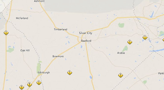
As you can see from the map below from NCDOT, the county's roads are steadily improving. Rockfish Road near McLauchlin Lakes, Golf Course Road at Twin Bridges, and Camden Road near the county line are all shut down, but for the most part the major thoroughfares are clear. There may still be some debris in areas, traffic cones blocking eroded pavement, water on the roadway and line crews out and about repairing damage - so drive carefully.

As of yesterday, Hoke County officials were working with the governor's office to have Hoke added to the counties with a FEMA declaration. We'll be following up with this as soon as we have more information.

The county's offices, post office, and most services are back up and running today. Hoke County Schools are closed tomorrow for students with an optional teacher workday for teachers, and we'll let you know as soon as we hear that officials have made a decision about Friday.

The Emergency Operations Center (EOC) is now closed, but citizens can call the Emergency Management office at 910-875-4126 for information.